

Glider Forecast

Описание на Glider Forecast
Glider Forecast gives you detailed weather forecast tailored exactly to the needs of free flight developed, tested and used by pilots.
Forecast data are available for Europe ranging from Iceland to Israel. Search for flying sites (takeoffs and landing places like Bassano or Dune de Pyla) or cities (Berlin or Bucharest).
Information available at a glance:
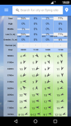
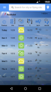
- cloud coverage (%),
- cloud top and bottom altitude levels,
- wind speed and direction at different altitudes,
- pressure,
- temperature,
- precipitation,
- intuitive lapse rate by color (green is good, red is bad lapse rate),
There is also a traditional Skew-T diagram.
Tap on the Skew-T diagram to check the temperature, dewpoint temperature, altitude and lapse rate data for more specific information.
Data are available in a variety of formats and units of measurement. The main categories are Metric and Imperial, but you can choose any combination of data formats, ex: wind direction shown by arrows, cardinal letters or degrees.
Available languages: English, German, Hungarian, Romanian.


